Along the Greek-Macedonian border. February and December 2016
At first glance, the Macedonian-Greek border looks tightly closed. Many will remember the pictures of double-lined fences, reinforced with barbed wire and patrolled by the Macedonian army in armoured vehicles. Many will also remember how refugees got stuck at the Greek border village Idomeni, their number reaching an estimated 12,000 to 14,000 people in mid-March 2016.
But these pictures are deceptive. The Macedonian fence covers only a tiny fraction of the border – less than 25 out of 246 kilometres: essentially the two spots where the border runs through flat plains.
Have a look at the following map: In the West, the Macedonian-Greek border runs through Lake Prespa, then over the Baba mountain range to a plain south of the city of Bitola. From there it climbs over the large Nidze mountain range and descends again to a plain around the Macedonian border town of Gevgelija, the main crossing point in 2015/16. Further East the border climbs through a few hills before it reaches Lake Dojran, a small summer holiday location. There it runs across the lake before ascending into the Belasica mountain range. Due to difficult terrain and the lack of security installations, many parts of the border are difficult to protect. This photo story takes you along the border, from the West to the East.

Map: Christian Altfuldisch/ESI
At its most Western point, the Macedonian-Greek border runs through the middle of Lake Prespa and then meets the lake’s Eastern shore. There is a road along the shore on the Macedonian side, but no official border crossing point.

Just a few metres after the little blue container of the Macedonian border police (left in the picture above, below the trees) the road ends. Someone approaching from the Greek side would have to cover the last kilometre from the village Lemos on an unmaintained dirt road.

Alternatively, a decent swimmer could cross the few hundred metres to a sandy beach on the Macedonian side. There are volleyball fields and a beach bar.

Eastwards, directly behind the Macedonian border post at Lake Prespa, hills ascend towards the Baba mountain range. There is a watch tower, but no fence.

The border climbs the hills and cuts through the Baba mountains before – further East – it descends into a plain in the Pelagonia valley, close to Bitola, Macedonia’s second biggest city. This picture shows the Baba mountains viewed from the village of Germijan.

Where the border hits the plain, a fence starts to run along the border eastwards for 5 kilometres until it reaches one of only three road border crossings between Greece and Macedonia (Niki-Medzitlija border crossing).
But it is easy to avoid the fence. If approaching the border from Greece, you can turn West before reaching the border and drive some 7 kilometres to the village Ethniko. From there it is a short walk up meadows with a few trees to the uninhabited monastery of St. Nicholas, located on Macedonian territory.

Before entering the monastery’s yard, you will be greeted by a border stone, pictured above and below. It still features the letters “SFRJ” for “Socialist Federal Republic of Yugoslavia”. The village in the background of the picture below is Ethniko.

East of the Niki-Medzitlija border crossing point the border runs for a few kilometres further East through the plain, but there is no fence. On the Macedonian side a road runs north of the border.

In the village of Kremenica, a few kilometres east of the border crossing, I met Pece, Toni and Cane, sitting against the back wall of a house that once was a shop. Next to them stood Igor and Dobre. Nothing lay between them and Greece except 1.5 kilometres of meadows. “There is no fence,” they said. “But also no refugees.”

The next Macedonian village further east along this road is Germijan. If one turns left from the main road, after 300 metres one sees an old sign (in Macedonian and French), hard to read and to make sense of: “ATTENTION! PASSAGE FRONTIERE. ARRET AVEC PERMISSION”.

Georgi, a local farmer, warned not to proceed: “They have cameras installed, and some 5 or 6 kilometres away they have two Jeeps. If someone crosses, they can be here in 15 minutes.” Up on the hill one can see a watchtower, presumably hosting the cameras.

A few kilometres further East the border climbs through soft hills and then ascends steeply to the Nidze mountain range (Voras in Greek). Directly at the border lies Mount Kajmakcalan (2,524 metres). Perched on top, a chapel honours soldiers fallen during the First World War. From the Greek side a ski lift takes you nearly to the top.

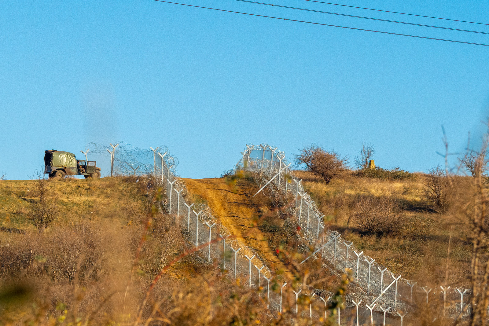
The border continues to run – completely unfenced – over lower mountains peaks and hills for nearly 100 km before it descends to the small plain around Gevgelija. Here is the main border crossing point between Greece and Macedonia (Evzonoi/Gevgelija-Bogorodica) where in the months preceding March 2016 more than a million refugees and migrants passed through. Macedonian security forces built a fence extending from both sides of this border crossing point. This section of the border is closely patrolled.

The fence covers the plain and then runs a few kilometres over a few hills further eastwards to Lake Dojran. There, on the Macedonian side, lies the small town of “Old Dojran” where a few new hotels and apartments mix with relics of the communist past, when large state-owned companies offered their workers cheap holidays in company-owned hotels.

After a stroll along the shore promenade or a very short drive one reaches the third official border crossing point, lying directly at the lake (Dojrani/Star Dojran).

The border then runs straight through the lake. Greece, with its splendid Mediterranean coastline and islands, has invested little in developing the shores of the lake. It appears easy to get to the lake on the Greek side close to the Greek border post. From there, it would take some 800 metres across the lake to reach the Macedonian shore, directly in front of the HIT Casino Hotel.
Beyond the lake, the border rises again – without any physical protection – through hills to the Belasica mountains where it meets the Greek-Bulgarian border.

Macedonia’s manpower to control more than 220 kilometres of mostly unprotected border is limited. The strength of the Macedonian border police, responsible also for the borders with Albania, Kosovo, Serbia and Bulgaria, is around 1,600. The Macedonian army has 8,000 professional soldiers, but only a fraction is deployed at the Greek-Macedonian border. In May 2016, the contingent was reduced from 800 to 400 soldiers. In addition there are a few dozen border police sent by а number of EU member states, in particular by the Visegrad countries, Austria and Croatia.
The pictures were taken on two trips, in February and in December 2016.